
File:The Fens England map.svg

此SVG文件的PNG预览的大小:658 × 599像素。 其他分辨率:264 × 240像素 | 527 × 480像素 | 843 × 768像素 | 1,124 × 1,024像素 | 2,248 × 2,048像素 | 1,740 × 1,585像素。
原始文件 (SVG文件,尺寸为1,740 × 1,585像素,文件大小:1.68 MB)
摘要
| 描述 |
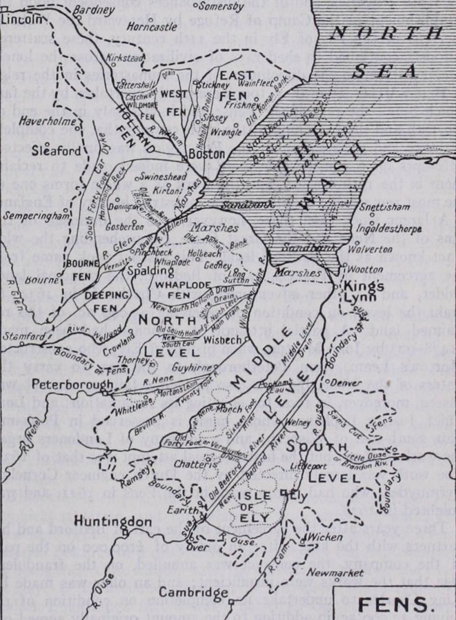
English: Map of The Fens England, places, levels, plains and and drains.
|
|||
| 日期 | ||||
| 来源 |
基于如下对象的个人作品:
Information from:
|
|||
| 作者 | Goran_tek-en | |||
| 授权 (二次使用本文件) |
本文件采用知识共享署名-相同方式共享 4.0 国际许可协议授权。 署名: Goran_tek-en
|
|||
| 其他版本 |
|
|||
| SVG开发 |


| 物体位置 | | 在以下服务上查看本图像和附近其他图像: OpenStreetMap |
|---|

文件历史
点击某个日期/时间查看对应时刻的文件。
| 日期/时间 | 缩略图 | 大小 | 用户 | 备注 | |
|---|---|---|---|---|---|
| 当前 | 2025年3月2日 (日) 15:47 | | 1,740 × 1,585(1.68 MB) | Goran tek-en | edits fens name requested by MOTORAL1987 |
| 2025年2月3日 (一) 14:39 |  | 1,740 × 1,585(1.68 MB) | Goran tek-en | edits requested by MOTORAL1987 | |
| 2025年1月26日 (日) 11:49 |  | 1,740 × 1,585(1.61 MB) | Goran tek-en | edits requested by MOTORAL1987 | |
| 2024年10月17日 (四) 12:42 |  | 1,740 × 1,585(1.6 MB) | Goran tek-en | spelling error, requested by MOTORAL1987 | |
| 2024年9月23日 (一) 16:18 |  | 1,740 × 1,585(1.6 MB) | Goran tek-en | edits requested by MOTORAL1987 | |
| 2024年4月19日 (五) 12:22 |  | 1,740 × 1,585(1.59 MB) | Goran tek-en | aded city requested by MOTORAL1987 | |
| 2024年4月18日 (四) 16:30 |  | 1,740 × 1,585(1.59 MB) | Goran tek-en | added city requested by MOTORAL1987 | |
| 2024年4月18日 (四) 14:09 |  | 1,740 × 1,585(1.58 MB) | Goran tek-en | added rivers requested by MOTORAL1987 | |
| 2024年4月16日 (二) 17:07 |  | 1,740 × 1,585(1.58 MB) | Goran tek-en | added stuff requested by MOTORAL1987 | |
| 2024年4月15日 (一) 18:00 |  | 1,740 × 1,585(1.57 MB) | Goran tek-en | stuff added as requested by MOTORAL1987 |
文件用途
以下页面使用本文件:
全域文件用途
以下其他wiki使用此文件:
- en.wikipedia.org上的用途
- es.wikipedia.org上的用途
- it.wikipedia.org上的用途
- simple.wikipedia.org上的用途