
File:Batum Treaty.svg

此 SVG 檔案的 PNG 預覽的大小:512 × 352 像素。 其他解析度:320 × 220 像素 | 640 × 440 像素 | 1,024 × 704 像素 | 1,280 × 880 像素 | 2,560 × 1,760 像素。
原始檔案 (SVG 檔案,表面大小:512 × 352 像素,檔案大小:876 KB)

摘要
| 描述 |
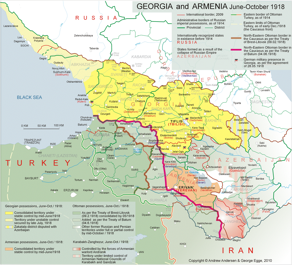
English: The treaty of Batum signed by the Caucasus states. Original can be found File:Treaty_of_Batum.png here, and also updated with minor changes taken from [this] |
| 日期 | |
| 來源 | 自己的作品 |
| 作者 | Peachy1621 |
授權條款
我,本作品的著作權持有者,決定用以下授權條款發佈本作品:
| 此檔案於創用 CC CC0 1.0 通用公有領域貢獻宣告下分發。 | |
| 在此宣告之下分發本作品者,已依據各國著作權法,在全世界放棄其對本作品所擁有的著作權及所有相關相似的法律權利,從而將本作品貢獻至公有領域。您可以複製、修改、分發和演示該作品,用於任何商業用途,所有這些都不需要請求授權。
|
檔案歷史
點選日期/時間以檢視該時間的檔案版本。
| 日期/時間 | 縮圖 | 尺寸 | 使用者 | 備註 | |
|---|---|---|---|---|---|
| 目前 | 2025年3月8日 (六) 23:03 | | 512 × 352(876 KB) | Peachy1621 | Some updates |
| 2025年2月20日 (四) 17:46 |  | 512 × 352(918 KB) | Peachy1621 | Nakhijevan was declared as under the RSFSR's suzerainty by Andranik, not an SSR* | |
| 2025年1月22日 (三) 20:47 |  | 512 × 352(901 KB) | Peachy1621 | Zagatala borders changed (used to be included within Georgia) to a neutral dashed line. Red army dark red outline fixed, and Ejmiatsin adjusted. Shushi Council updated as well with a dashed line for a border. | |
| 2025年1月8日 (三) 07:32 |  | 512 × 352(897 KB) | Peachy1621 | Added the Armenian Nakhijevan SSR (declared by Andranik Ozanian in mid-1918) and fixed Zagatala, as the borders near Georgia and Azerbaijan were doing some weird z-fighting of some sort. | |
| 2025年1月8日 (三) 05:41 |  | 512 × 352(835 KB) | Peachy1621 | Color of the lakes and rivers changed to match the coast. | |
| 2024年9月25日 (三) 22:29 |  | 512 × 352(770 KB) | Peachy1621 | {{Information |Description= |Source= |Date= |Author= |Permission= |other_versions= }} | |
| 2024年9月25日 (三) 22:20 |  | 512 × 352(778 KB) | Peachy1621 | Map fixed (borders were adjusted, and some stuff reinstated and renamed.) | |
| 2024年6月4日 (二) 02:52 |  | 512 × 352(736 KB) | Peachy1621 | Uploaded own work with UploadWizard |
檔案用途
下列頁面有用到此檔案:
全域檔案使用狀況
以下其他 wiki 使用了這個檔案:
- en.wikipedia.org 的使用狀況
- fa.wikipedia.org 的使用狀況
- tr.wikipedia.org 的使用狀況