
File:Political map of England 1140.PNG
預覽大小:736 × 600 像素。 其他解析度:295 × 240 像素 | 589 × 480 像素 | 943 × 768 像素 | 1,257 × 1,024 像素 | 1,489 × 1,213 像素。
原始檔案 (1,489 × 1,213 像素,檔案大小:163 KB,MIME 類型:image/png)

|
本圖片是以PNG、GIF或JPEG格式上傳。然而,其中包含的資料或訊息,應該重新建立成可縮放向量圖形(SVG)檔案,以更有效率或更準確的方式儲存。如有可能,請上傳本圖片的SVG格式版本。在上傳之後,請修改維基各姊妹計畫中所有使用舊版圖片的條目(列在圖像連結章節中),替換為新版圖片,並在舊圖片的描述頁中加入{{Vector version available|新圖片名稱.svg}}模板,同時移除本模板。
|
摘要
| 描述 |
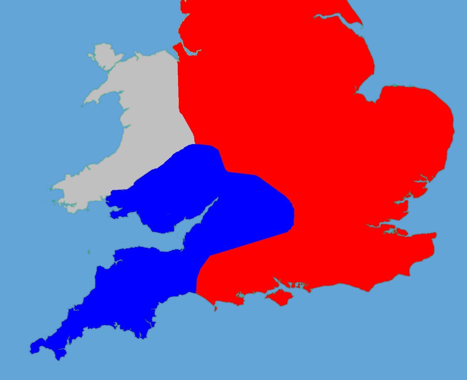
English: A political map of England in 1140 |
| 日期 | (UTC) |
| 來源 |
個人作品,使用:
|
| 作者 |
|
| 這是一張修飾過的圖片,即本圖片是用軟體修改過後的版本,修改的方式或內容有:Retouched, historical data added。原版圖片來源:Gb4dot.svg。修改者:Hchc2009。
|
我,本作品的著作權持有者,決定用以下授權條款發佈本作品:
| 我,此作品的版權所有人,釋出此作品至公共領域。此授權條款在全世界均適用。 這可能在某些國家不合法,如果是的話: 我授予任何人有權利使用此作品於任何用途,除受法律約束外,不受任何限制。 |
原始上傳日誌
This image is a derivative work of the following images:
- File:Gb4dot.svg licensed with PD-self
Uploaded with derivativeFX
檔案歷史
點選日期/時間以檢視該時間的檔案版本。
| 日期/時間 | 縮圖 | 尺寸 | 用戶 | 備註 | |
|---|---|---|---|---|---|
| 目前 | 2011年5月27日 (五) 18:14 | | 1,489 × 1,213(163 KB) | Hchc2009 | Trimmed to just show the south and Wales |
| 2011年5月27日 (五) 18:11 |  | 1,489 × 1,753(224 KB) | Hchc2009 | {{Information |Description=A political map of England in 1140, based on data in Jim Bradbury's book "Stephen and Matilda", p.89 and p.180. The original map was a blank locator map for Great Britain. The idea is to superimpose Image:dot4gb.svg at the |
檔案用途
下列頁面有用到此檔案:
全域檔案使用狀況
以下其他 wiki 使用了這個檔案:
- bg.wikipedia.org 的使用狀況
- en.wikipedia.org 的使用狀況
- gl.wikipedia.org 的使用狀況
- hu.wikipedia.org 的使用狀況
- id.wikipedia.org 的使用狀況
- it.wikipedia.org 的使用狀況
- ja.wikipedia.org 的使用狀況
- no.wikipedia.org 的使用狀況
- pt.wikipedia.org 的使用狀況
- ru.wikipedia.org 的使用狀況
- tr.wikipedia.org 的使用狀況