約貝州
外觀
| 約貝州 Yobe | |
|---|---|
| 州 | |
| 綽號:Pride of the Sahel | |
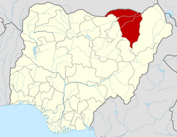
 Location of Yobe State in Nigeria | |
| 坐標:12°00′N 11°30′E / 12.000°N 11.500°E | |
| 國家 | |
| Date created | 27 August 1991 |
| 首府 | 達馬圖魯 |
| 面積 | |
| • 總計 | 45,502 平方公里(17,568 平方英里) |
| 面積排名 | 6th of 36 |
| 人口(2006 census) | |
| • 總計 | 2,321,339[1]人 |
| • 估計(2022[2]) | 3,649,600 |
| • 排名 | 32nd of 36 |
| • 密度 | 51人/平方公里(132人/平方英里) |
| GDP (PPP) | |
| • Year | 2021 |
| • Total | $7.05 billion[3] 36th of 36 |
| • Per capita | $1,797[3] 35th of 36 |
| 時區 | WAT(UTC+01) |
| postal code | 620001 |
| 電話區號 | +234 |
| ISO 3166碼 | NG-YO |
| HDI (2022) | 0.439[4] low · 31st of 37 |
約貝州(英文:Yobe State)是尼日利亞東北部的一個州,首府達馬圖魯,原為舊博爾諾州的一部分,1991年8月27日分割成立新州,面積45,502平方公里,2005年估計人口約253萬,大多數信奉伊斯蘭教。
州內實施伊斯蘭教法。
| 這是一篇與尼日利亞地理相關的小作品。您可以透過編輯或修訂擴充其內容。 |
- ^ 2006 PHC Priority Tables – NATIONAL POPULATION COMMISSION. population.gov.ng. [10 October 2017] (美國英語).
- ^ Yobe State: Subdivision. www.citypopulation.de. [2024-02-05].
- ^ 3.0 3.1 Okeowo, Gabriel; Fatoba, Iyanuoluwa (編). State of States 2022 Edition (PDF). Budgit.org. BudgIT. 13 October 2022 [7 March 2023].
- ^ Sub-national HDI - Area Database - Global Data Lab. hdi.globaldatalab.org. [13 September 2018] (英語).


